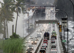
From Calcutta, India, to Seattle, Wash. and beyond, the MJO can bring storms and plenty of rain in wet years. PNNL researchers are using field data and NERSC supercomputers to better model how the MJO operates and understand its interaction regional weather systems around the world. Image: PNNL
An Alaska-sized pulse of clouds and precipitation congregates over the Indian Ocean and lumbers east. Soon it will be mustering monsoons over Mumbai and developing downpours for Portland. So big, so enigmatic, it has a name: Madden-Julian Oscillation (MJO).
The MJO occurs on its own timetable—every 30 to 60 days—but its worldwide impact spurs scientists to unlock its secrets. The ultimate answer? Timely preparation for the precipitation havoc it brings—and insight into how it will behave when pressured by a warming climate.
Better understanding of the MJO is vital. Its unpredictability makes it harder for weather forecasting many regions around the world including Western US, Australia, and South Asia. Because many parts of the world rely on monsoon rain for their yearly water supply, preparation for more or less rain is critical. For the U.S. West Coast, the MJO can influence atmospheric rivers as well as the El Niño/La Niña cycle, which affect the probability of floods and droughts in those states. In fact, the MJO has worldwide precipitation influence, stretching all the way to the African continent, especially for Sub-Saharan and Sahel regions. The MJO’s influence in all these regions can affect crops, infrastructure and daily survival for some.
Despite decades of work, however, simulating the MJO in climate models and understanding the instabilities that drive it remain a significant challenge.
The problem has been we don’t have fine enough resolution to capture the cloud processes that lie at the core of MJO dynamics,” said Samson Hagos, an atmospheric scientist at Pacific Northwest National Laboratory (PNNL) who has spent the last eight years studying the MJO process and its impact on climate models. “There are cloud processes we cannot explicitly resolve with the current generation of climate models and computational resources, so we have to rely on parameterizations based on theories. So there is a need for computational resources to achieve the model resolution we need.”
Improving Weather Forecasting
Working to reveal the MJO’s cycle secrets, Samson and colleagues from PNNL used NERSC’s Edison supercomputer and data gathered during a field campaign over the Indian Ocean to identify the processes that are responsible for too much precipitation in the models, especially during the low-rainfall period of the MJO signal.
The researchers took 11 configurations of regional and global models—including a regional cloud-permitting model (WRF), a regional model with various cumulus parameterizations (WRF) and a global variable-resolution model (MPAS) with a high-resolution region centered over the tropical Indian Ocean—to perform their simulations. They quantified the range of possible answers using a linear statistical model on various specific processes governing the overall performance of the simulations in capturing the MJO.
The simulations, which used 2,400 cores and about 250,000 computer hours on Edison, found that the mismatches are related to the fact that most of the models get the relationship between environmental moisture and precipitation wrong, producing more precipitation than is observed for the same moisture content in the environment, especially in drier environments.
This error, which is related to the representation of how clouds entrain (mix with) the environmental moisture accounts for up to 30% of the overall model precipitation error,” Hagos said. “The variance is most pronounced during the suppressed or dry phase of the MJO.”
Their findings, published in the Journal of Climate, show the importance of accurately representing the interaction of clouds with the environmental air for accurate modeling of the MJO.
We hope to do this on a global scale with very fine resolution so we do not have to make too many simplifying assumptions in constructing parameterizations,” Hagos said. “We hope this will help us improve the prediction skills of models not only for MJO but also for the diurnal cycle of convection over land and monsoons and how they all respond to global warming.”
This research was supported by the Department of Energy (DOE) Office of Science, Biological and Environmental Research under the Atmospheric System Research Program and the Regional and Global Climate Modeling Program. Data collected on Gan Island during the AMIE/DYNAMO field campaign—including radar, lidar, surface MET and sounding data—were obtained from the DOE as part of the Atmospheric Radiation Measurement Climate Research Facility.
This NERSC article was adapted from materials provided by Pacific Northwest National Laboratory.


