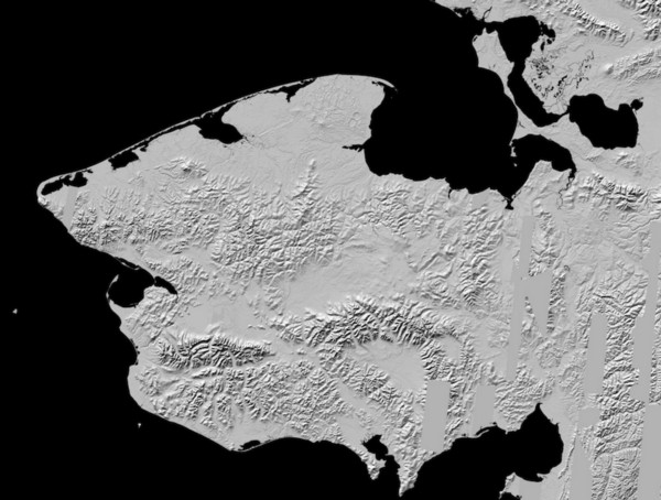
 Today, the National Geospatial-Intelligence Agency and NSF released 3-D topographic maps that show Alaska’s terrain in greater detail than ever before. Powered by the Blue Waters supercomputer, the maps are the result of a White House Arctic initiative to inform better decision-making in the Arctic.
Paul Morin, head of the University of Minnesota’s Polar Geospatial Center (PGC), and his ArcticDEM project collaborators from Ohio State and Cornell universities are using Blue Waters to create digital elevation models, or DEMs, that are swiftly changing what we know about the Arctic. A DEM is a computer-generated 3D topographic map that shows the height of everything on the earth’s surface.
Current elevation models for the Arctic have a resolution of one kilometer—Morin’s models offer a resolution of five meters or less, and are much more accurate at gaging height. The jump in detail will help scientists track ice loss better, and enable a host of other research.
Alaska’s DEMs are the first maps released by the project, but their goal is to cover the whole Arctic with the first high-resolution, high-quality and openly distributed set of DEMS of all arctic landmasses above 60 degree N.
The project was started in response to a January 2015 executive order calling for enhanced coordination of national efforts in the Arctic, which includes all of Alaska, all of Greenland, most of Canada and the Russian Kamchatka Peninsula, and covers an area approximately twice as large as the continental United States.
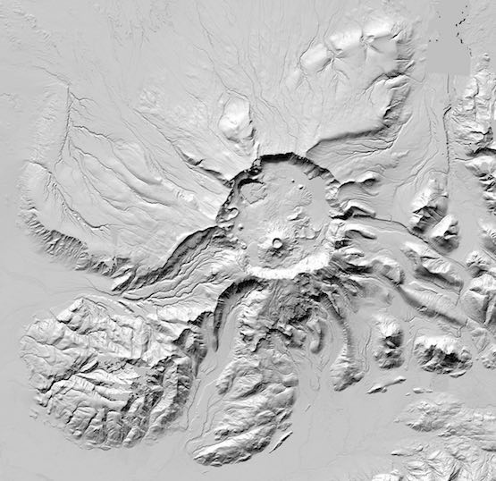
Mount Aniakchak is a volcanic caldera located in the Aniakchak National Monument and Preserve in the Aleutian Range of Alaska. Aniakchak is one of the wildest and least visited places in the National Park System. The area was proclaimed a National Monument on December 1, 1978.
The maps were created using data provided by the National Geospacial Intelligence Agency from commercial satellites owned and operated by Colorado-based DigitalGlobe, Inc. Each day the satellites collect image data over an area equivalent of California in the Arctic. Over a period of a week PGC can receive up to 30 terabytes of data.
The ArcticDEM project feeds the data into Blue Waters to create the digital elevation models, using software collaborators at Ohio State University developed to automate the processes. The software takes parts of two images, tries to predict where one pixel is on the other, manipulates to minimize error, and creates a new image and measures the height of two by two meter squares for all 20 trillion cells in the Arctic.
“We at Blue Waters are excited to expedite this analysis by providing Blue Waters’ unique mix of a balanced, capable system and flexible support services to the PCG team. It is a great example of what Blue Waters does to make grand challenge science possible on the order of a year rather than a decade,” said Bill Kramer, Blue Waters Director and Principal Investigator at NCSA.
We can’t live without Blue Waters now,” said Morin. “The supercomputer itself, the tools the Blue Waters team at NCSA developed, the techniques they’ve come up with in using this hardware. Blue Waters is changing the way digital terrain is made and that is changing how science is done in the Arctic.”
ArcticDEMs have a horizontal resolution of two meters with an error of less than four meters. The current uniform DEM for the Arctic has a resolution of a kilometer and with a vertical accuracy of sometimes hundreds of meters.
This is quite an astounding thing to be producing topography for 30 degrees of the globe with supercomputers and 1-foot resolution satellites,” said Morin. “I’ve never seen anything like it.”
The production of comprehensive, fine-scale Arctic DEMs is transforming the Arctic research community and Arctic society. The DEMs provide time-stamped observations of ice extent and ice surface height and can be examined within the context of changing environmental factors. The detail of the DEMs allows the evolution of surface water flows on glaciers to be examined, down to the level of individual lakes and streams, with ramifications for wetlands, ecosystems, and wildlife management and sustainability.
New ArcticDEM data will provide information about ice and volcano interactions, process geomorphology, tectonic geomorphology, plate boundary interactions, fault expressions, fault evolution, glacial geomorphology, and solid earth geodynamics derived from bending lake shorelines.
Moreover, atmospheric science pursuits such as the study of microclimates, valley-scale atmospheric dynamics and foehn winds will use the new fine-scale topographies for downscaled or micro-region atmospheric models. Communities are also likely to use the DEMs to anticipate and address permafrost impacts, rising sea level, floodplain delimitation and disaster management.