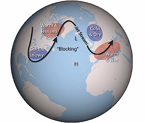
NAO negative phase. Diagram: Gardiner & Herring, NOAA
In a paper published today in Nature Geoscience, scientists at the Met Office have demonstrated significant advances in predicting up to one year ahead the phases of the North Atlantic Oscillation (NAO), which drives European and North American winter variability. The NAO – a large-scale gradient in air pressure measured between low pressure around Iceland and high pressure around the Azores – is the primary driver of winter climate variability for Europe.
In winters when the pressure gradient between the areas of high and low pressure is greater than average, the winter NAO is said to be ‘positive’ and northern Europe experiences mild and stormy conditions. The opposing ‘negative’ phase is associated with more settled dry and cold winter conditions, such as the extremely cold winter of 2009-2010, when the UK and northern Europe were dry, but freezing cold, for months.
Dr Nick Dunstone is the Met Office’s lead author. He said: “Understanding and predicting the changes in the North Atlantic Oscillation could have significant economic benefits including potential boosts in climate services for a range of sectors including transport, energy, water management and the insurance industry.
Two years ago we showed skill in predicting the winter NAO up to one month ahead,” said Dunstone. “Our latest research builds on that gain in skill in predicting the coming winter, but also reveals, for the first time, modest but significant skill in predicting the phase of the NAO one year ahead. This is an exciting first step in developing useful winter climate predictions on longer timescales.”
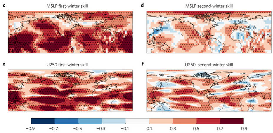
Winter is coming! Maps of skill (correlation) for predicting the first- and second-winter MSLP. e,f, As c,d, but for predicting the upper-tropospheric (250 hPa) zonal winds. Stippled regions are significant at the 5% level according to a Student’s t-test.
This discovery was made possible thanks to increased Met Office supercomputer capacity. This allowed the team to increase the resolution of the climate model and test the retrospective skill of their forecasts over the 35-year period from 1980 onwards.
The Met Office long-range outlook, made in real-time one month ahead of winter, gave good advice ahead of last winter’s flooding. Prof Adam Scaife, co-author and head of Met Office Monthly to Decadal Prediction, explains: “From as early as last October and November, our seasonal forecast system showed an enhanced risk of storms and very wet conditions for the early part of winter 2015/16 and then a transition to colder, drier conditions during late winter.
This year is different: current signals suggest that the start to winter is likely to be cooler and drier than in 2015.”
The paper – Skilful predictions of the winter North Atlantic Oscillation one year ahead – is published today in the journal Nature Geoscience. This paper focuses on the effect of the NAO on Europe and North America. It forms part of wider analysis that also focuses on the link between the NAO and winter variability in China.
Source: UK Met Office