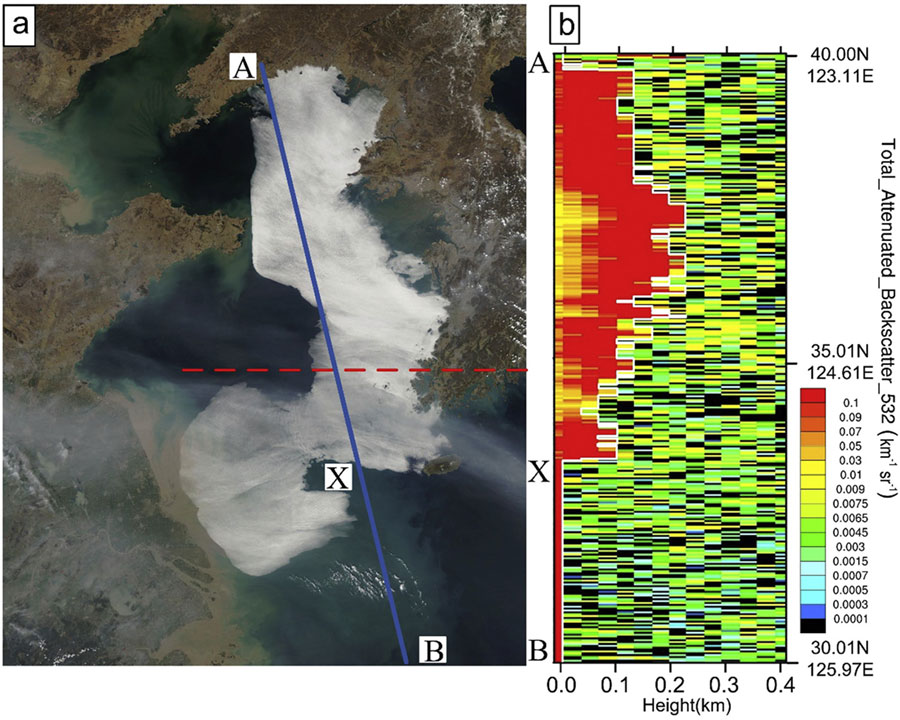

This image shows the vertical cross-section of backscattering coefficients (indication of water droplets, i.e., sea fog) along the blue line AB. The red dashed line is used to roughly separate thick fog (to the north) and thin fog (to the south). Courtesy of the Center for Analysis and Prediction of Storms (CAPS), University of Oklahoma.
Over at the XSEDE blog, Kim Bruch from SDSC writes that an international team of researchers is using supercomputers to shed new light on how and why a particular type of sea fog forms. Through fog simulation, they hope to provide more accurate fog predictions that help reduce the number of maritime mishaps.
As published in Atmospheric Research, the study focused on a significant sea fog event that stretched approximately 400 miles across the Yellow Sea and its surrounding land. Images captured by the Moderate Resolution Imaging Spectroradiometer (MODIS) on the Aqua satellite allowed the research team to better explain the sensitivity of sea fog simulations to vertical resolution. The researchers have been using the Comet supercomputer based at the San Diego Supercomputer Center (SDSC) at UC San Diego. To-date, the team has used about 2 million core hours.
We have been getting used to the system, and all of our modeling systems have now been installed on Comet,” said Xiao-Ming Hu, a researcher with the Center for Analysis and Prediction of Storms (CAPS) at the University of Oklahoma and principal investigator for the project. “The system’s storage capacity enabled us to save useful model outputs for analysis until the research was eventually published, which was critical. All of this really saved our team a great deal of time and money.”
NASA data affirms that spring fogs can occur for 50-80 days per year across the Yellow Sea. The fogs occur within the marine atmospheric boundary layer and are responsible for as many as half of the shipping accidents at the Qingdao port, according to the Chinese government. The primary type of fog covering the Yellow Sea is called advection fog, which usually forms when warm, moist air moves into areas with a cold surface.
The recently published study was conducted by Ocean University of China researchers Yue Yang and Shanhong Gao, in addition to Hu and Yongming Wang from the University of Oklahoma. The team used the Weather Research and Forecasting (WRF) model to simulate the selected sea fog and examined sensitivity of the WRF simulations to different vertical resolutions in order to provide insight regarding how the fogs form, as well as developing optimal model configurations to better predict sea fogs.
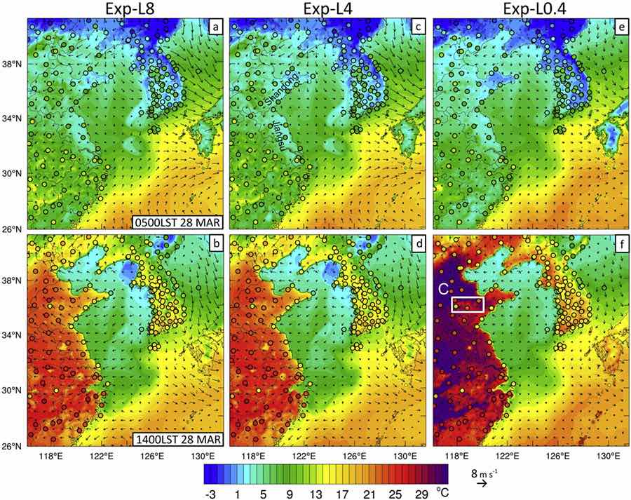
Evaluation of surface temperatures simulated with different vertical resolutions (from left to right) using station data over eastern Asia archived by NOAA. This helped researchers identify the optimal vertical resolution for accurately simulating sea fog. Courtesy of the Center for Analysis and Prediction of Storms (CAPS), University of Oklahoma.
While many previous studies focused on the effects of vertical resolution to better predict atmospheric events such as precipitation and hurricanes, this study aimed to achieve the best prediction of sea fogs using refined vertical resolution, according to the researchers.
Inaccurate predictions of sea fog over the Yellow Sea pose a severe risk or damage to many human activities such as aviation, shipping, and the general business economy,” explained Hu. “Accurate predictions of sea fogs involve a few parameterizations for the atmospheric boundary layer and microphysics processes, all of which requires appropriate resolutions. Finding the optimal configurations among resolutions and parameterization schemes is not only beneficial for predicting sea fogs as demonstrated in this study, but also helps researchers to better understand and predict other meteorological events.”
The optimal model configurations by this study were adopted by the sea fog forecasting system from the Ocean University of China about one year ago, based on draft manuscripts of this research study. The Ocean University of China and University of Oklahoma researchers continue their collaboration to improve meteorological forecasting models in order to reduce the damage from meteorological disasters around the world, with support from supercomputers such as Comet.
These studies have large-scale computing requirements that can only be satisfied by large supercomputers,” said Hu. “Without access to high-performance computing, CAPS would not be nearly as productive.”
The study, “Sensitivity of WRF Simulations with the YSU PBL Scheme to the Lowest Model Level Height for a Sea Fog Event over the Yellow Sea,” was published in the January 1, 2019 issue of Atmospheric Research. Researchers include Yue Yang and Shanhong Gao, with the Ocean University of China; and Xiao-Ming Hu and Yongming, with the University of Oklahoma.
Source: XSEDE