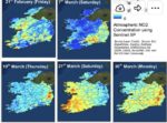
Satellite Data analyzed by scientists from ICHEC (Irish Centre for High-End Computing) using European Space Agency Sentinel 5-P satellite data shows evidence of Nitrogen Dioxide (NO2) emissions in a number of rural areas during February and March 2020. “ICHEC released imagery today, April 3 in which the scientists observed general reductions in emissions (blue areas of the maps) from the lower levels of activity in the economy due to COVID-19 but also observed a few spikes (red areas) on some dates, most likely associated with fires in rural areas.”
At the Convergence of HPC, AI and Quantum